When people hear “UNESCO” in Indonesia, they usually think of temples, monuments, or a handful of famous national parks. That makes sense, but it leaves out some of the most revealing landscapes in the country. We like to consider places beyond these, and include the experience of visiting them. For us, UNESCO Global Geoparks are some of the best places to understand Indonesia properly because they explain why the land looks like this, why communities live where they do, and how geology, ecology, and culture keep shaping one another in everyday life.
UNESCO Global Geoparks are not just scenic places with a badge attached. UNESCO defines them as single, unified geographical areas where sites and landscapes of international geological significance are managed through protection, education, and sustainable development. That framework works particularly well in Indonesia because this is an archipelago built by tectonic collision, volcanic force, marine systems, and long histories of local adaptation to landscapes that are both unstable and incredibly productive.
We use geoparks as a way of helping guests read Indonesia better. A volcano stops being just a dramatic backdrop. A karst wall stops being just a nice photograph. An island chain starts to make sense as part of a much older geological story. That shift matters to us, because it turns travel into understanding rather than simple movement between highlights.
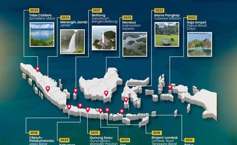
As of 2026, Indonesia has twelve UNESCO Global Geoparks, including Batur, Belitong, Ciletuh-Palabuhanratu, Gunung Sewu, Ijen, Kebumen, Maros Pangkep, Merangin Jambi, Meratus, Raja Ampat, Rinjani-Lombok, and Toba Caldera. We do not work with them as a checklist. We use them as anchors for different kinds of journeys, from boat-based exploration to soft trekking, cave landscapes, volcanic routes, and interpretation-rich cultural travel.
Why geoparks matter in Indonesia
One of the reasons we keep coming back to geoparks is that they naturally connect the large-scale story with the local one. UNESCO’s geopark model is not only about geological heritage. It also emphasises education, conservation, and sustainable local development. In Indonesia, that matters because the landscapes that look spectacular to visitors are also lived-in landscapes shaped by farming, fishing, settlement, ritual, trade, and inherited local knowledge.
That is how we approach them. We are not interested in simply saying, “this place is geologically significant.” We want to show what that geological significance has actually done. Why does water move the way it does here. Why are caves central rather than incidental. Why did villages emerge in this pattern. Why are certain crossings, ridges, lakes, or coastlines so important. The geology is the foundation, but the experience becomes meaningful when guests see how life sits inside it.
This is also why geoparks suit the way we work. They reward interpretation. Anyone can bring a guest to a viewpoint. It takes more care to build a route that helps someone understand what they are looking at and why it matters. That is where local knowledge, pacing, and good guiding make the difference.
Maros Pangkep: where the story gets layered
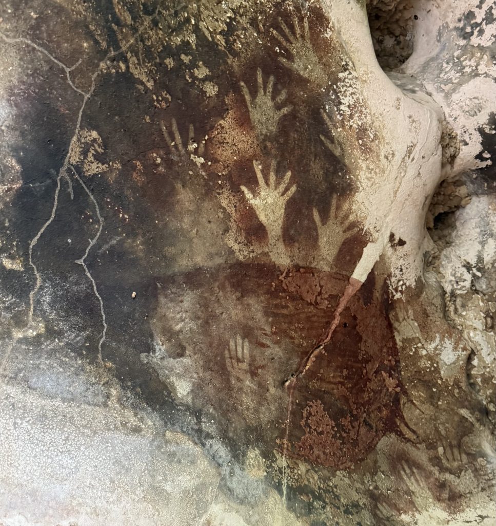
If we had to choose one geopark that shows why this category matters, Maros Pangkep would be high on the list. UNESCO recognises Maros Pangkep for its globally significant karst landscape in South Sulawesi, its extensive cave systems, and its position along the Wallace Line, one of the most important biogeographical boundaries on Earth. It is a place where geology, archaeology, biodiversity, and cultural context all sit close together.
What makes Maros work so well for us is that it rewards curiosity. The area is visually striking straight away, with tower karst, cave systems, waterways, and limestone formations that feel almost sculpted. But the real value comes when you slow down and start reading it properly. Once guests understand that this landscape is part of a deeper story about Sulawesi’s geological history and the movement of species across Wallacea, the whole place changes.
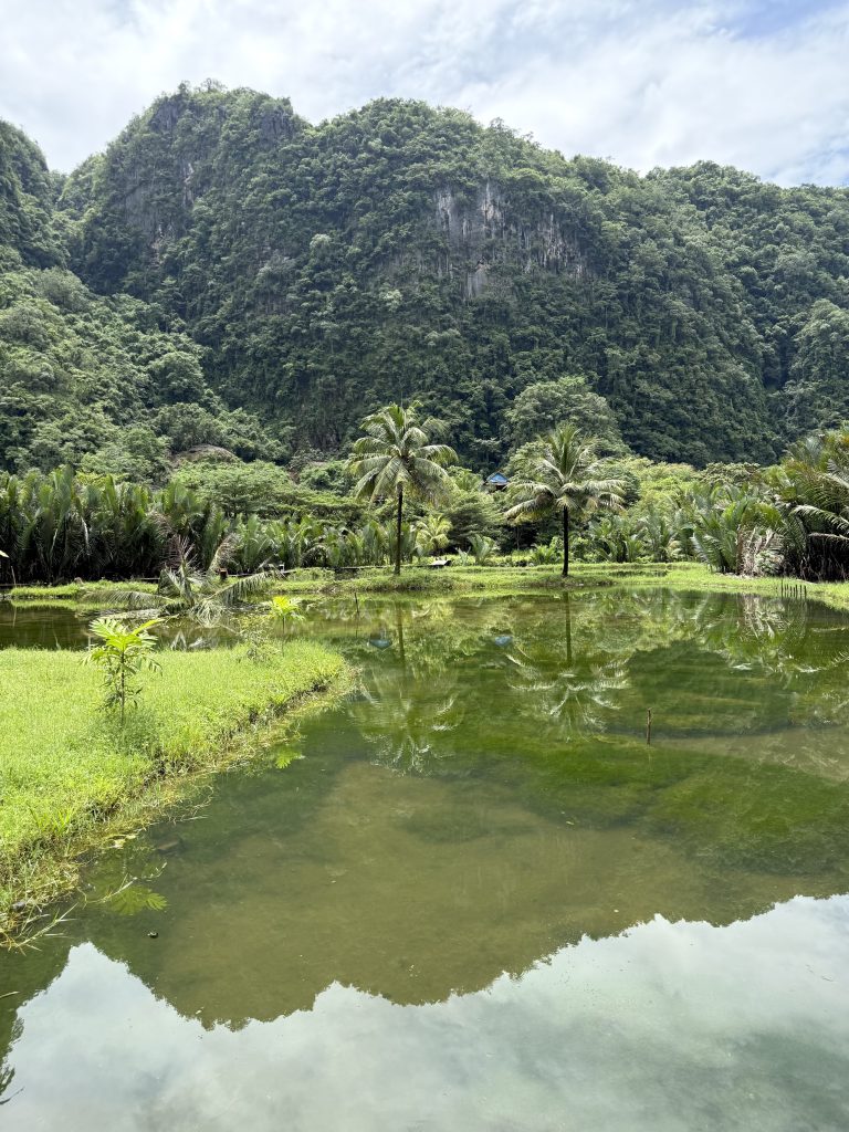
We also like Maros because it does not feel over-processed. It still has that sense of discovery that matters in Indonesia. You can stand in a karst environment, move through caves, and talk about deep time, ancient environments, and human traces without the whole experience feeling flattened into a packaged attraction.
For Wicked, that is exactly the kind of place we want to work in. It is layered, it needs explaining, and it leaves guests with a stronger mental map of the country. After a good experience in Maros, people stop seeing Indonesia as a series of disconnected islands and start seeing patterns in the land itself.
The cave image works especially well if you want to emphasise the human history and archaeological dimension of Maros, not just the karst scenery.
Raja Ampat: geology beneath the beauty
Raja Ampat is usually sold on looks alone, which is understandable but incomplete. UNESCO recognises Raja Ampat as a Global Geopark because of its geological significance, including ancient rock formations and the processes that created its distinctive karst island landscapes. The scenery is spectacular, but the geology is not a side note. It is the reason the place exists in this form.
We like using Raja Ampat to move guests beyond the postcard version of Indonesia. Once people understand that these islands are part of a much deeper geological archive, the journey changes. It is no longer just island-hopping between beautiful reefs and lookouts. It becomes a way of moving through a landscape shaped by tectonics, marine processes, and local stewardship.
That matters operationally too. Raja Ampat works best when the journey has rhythm and explanation. Boat routes, viewpoints, village stops, and marine experiences all make more sense when they are tied into one coherent reading of the landscape. That is the sort of interpretation we care about, because it turns a famous destination into a meaningful one.
This is the obvious hero-style geopark image because it shows exactly what people think Raja Ampat is, while giving you room in the text to explain that it is more than that.
Batur: reading Bali through a caldera
Bali gets flattened by tourism language all the time, which is one reason we like talking about Batur. Batur Geopark gives a much better entry point into the island because it shows that Bali is not just beaches and temples. It is a volcanic landscape where geology has shaped agriculture, settlement, water systems, and spiritual life for a very long time.
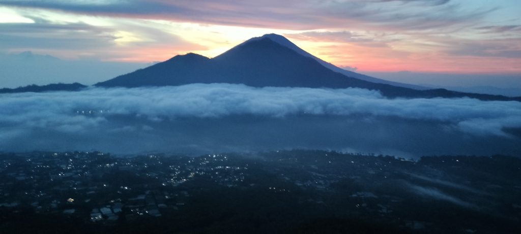
We think Batur works best when it is experienced as more than a sunrise box to tick. Yes, the views matter, and the caldera is visually strong, but the real value is in understanding the landscape as a system. The volcanic terrain, the lake, the surrounding communities, and the wider island logic all become clearer once guests know how the caldera works and why it matters.
This is a good example of how geoparks cut through cliché. Once guests see Bali through geology, the island starts to make more sense. The land stops being background and becomes part of the explanation.
Toba Caldera: where geological time feels close
Toba Caldera in North Sumatra is one of the strongest examples of why geoparks matter. UNESCO describes it as the result of one of the most powerful eruptions in Earth’s history, around 75,000 years ago, producing the huge caldera now occupied by Lake Toba. That sounds abstract until you are there. Then the scale becomes physical. The lake, the high walls, Samosir Island, and the surrounding uplands all make the size of that event feel real.
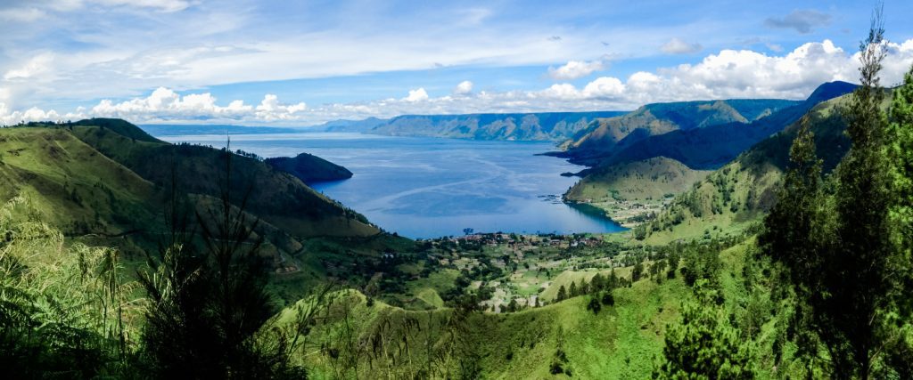
For guests, Toba often becomes the place where geological time stops feeling theoretical. You do not need a specialist background to grasp that something enormous happened here. The landscape tells you. And because this is Indonesia, the geological story never stands alone. Around Toba, it sits alongside Batak cultural landscapes, settlement history, and daily life around the lake.
Toba is also worth mentioning because UNESCO recognition brings accountability, not just prestige. The geopark faced reassessment after concerns about management standards, which underlines an important point: labels matter, but stewardship matters more. We think that honesty is important. A geopark is meaningful when it is looked after properly, interpreted well, and connected to real local benefit.
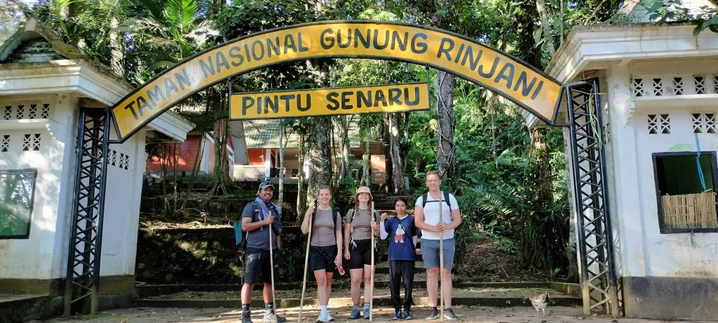
Rinjani and Ijen: Indonesia’s volcanic spine on foot
Some geoparks are best understood while moving through them, and Rinjani-Lombok and Ijen fall into that category. Rinjani-Lombok is built around a major volcanic system with the crater lake Segara Anak at its centre, while Ijen is known for its crater landscape and volcanic features in East Java.
What we like about these landscapes is that they make Indonesia’s tectonic reality feel immediate. The country is dramatic because it is still being formed. Walking through volcanic terrain, guests are not just admiring scenery. They are seeing an active archipelago whose landforms continue to shape routes, livelihoods, ecosystems, and the practical way people inhabit place.
That is one reason geopark interpretation works across different kinds of travel. You do not need a full expedition to benefit from understanding volcanic landscapes. Even on gentler itineraries, people connect more deeply with Indonesia when they know what kind of country they are actually moving through.
How we actually use geoparks in our trips
For us, geoparks are not niche add-ons for geology enthusiasts. They are part of how we build better journeys in Indonesia. They reward pacing, curiosity, and good interpretation, which fits the way we like to work.
In practical terms, that means a few things:
- We use geoparks to give structure to an itinerary, not just to add another stop.
- We choose routes and viewpoints that reveal something about the landscape, not only the most photographed spots.
- We bring in local context, because a geopark is never only about geology in Indonesia.
- We treat these places as environments to understand, not just scenery to consume.
That approach works for adventure travel, but it also works much more broadly. If we can help guests move clearly through remote karst landscapes, volcanic systems, and island geographies, that gives confidence across the rest of the journey too. It shows that we understand Indonesia not just as a destination, but as a set of landscapes with logic.
Why we keep coming back to Maros
Maros Pangkep deserves one more mention because it captures so much of what we value. It is scientifically important, visually strong, culturally layered, and still slightly outside the most overused tourism circuits. That combination is rare.
We keep coming back to places like Maros because they change how guests think. After a good experience there, people start to read the rest of Indonesia differently. They notice geological structure, ecological boundaries, water systems, settlement logic, and the way local knowledge fits into all of it. That shift is exactly what we are after. Once it happens, every other island begins to make more sense.
Indonesia’s geoparks are part of the main story
UNESCO Global Geoparks are sometimes treated as secondary to World Heritage Sites, but in Indonesia they should not be. They are one of the best ways to understand the country because they connect Earth history, conservation, education, and community experience in one working framework.
For us, that makes them central, not peripheral. They help explain why Indonesia looks like this, why it feels like this, and why meaningful travel here works best when it is grounded in people who can connect the landscape to the lives built within it.
That is really why we visit them. Not because “geopark” sounds good in a programme, but because these places make Indonesia make sense.


